Find out about local climate change predictions and what Council is doing.
Jump to a Topic
East Gippsland Shire Council is preparing for the impacts of climate change and working to build resilience across our region. Our focus is on understanding risks, reducing emissions, and supporting community action.
Key initiatives include:
Climate Risk Analysis: Assessing how extreme weather, flooding, and bushfire risks affect local infrastructure.
Climate Projections: Using the latest data to guide planning and adaptation.
Understanding Community Emissions: Tracking our region’s carbon footprint.
Regional Collaboration: Partnering through GACA to deliver shared climate solutions.
Explore this section for insights, data, and ways to get involved in building a climate-ready East Gippsland.
Climate Risk Analysis
We are undertaking a comprehensive Climate Risk Analysis to better understand how climate change will impact Council-managed infrastructure across the region. This project is a key step in preparing for future conditions and ensuring that public assets are designed and maintained with resilience in mind.
The analysis focuses on identifying risks such as:
Heat stress and drying impacts
More intense storms and flooding
Coastal inundation and sea level rise
Bushfire vulnerability
By mapping these risks, Council aims to guide future investment decisions and infrastructure design standards. This includes adapting roads, bridges, and community facilities to withstand more frequent and severe climate-related events.
Council is already investing in more resilient infrastructure, such as upgrading roads in flood-prone areas and exploring opportunities to “build back better” after disaster events. The Climate Risk Analysis will support these efforts by providing evidence-based insights and helping prioritise upgrades.
Council is also advocating for state-wide guidance and funding support, ensuring that local governments have access to the tools and resources needed to respond effectively to climate risks.
East Gippsland Climate Projections
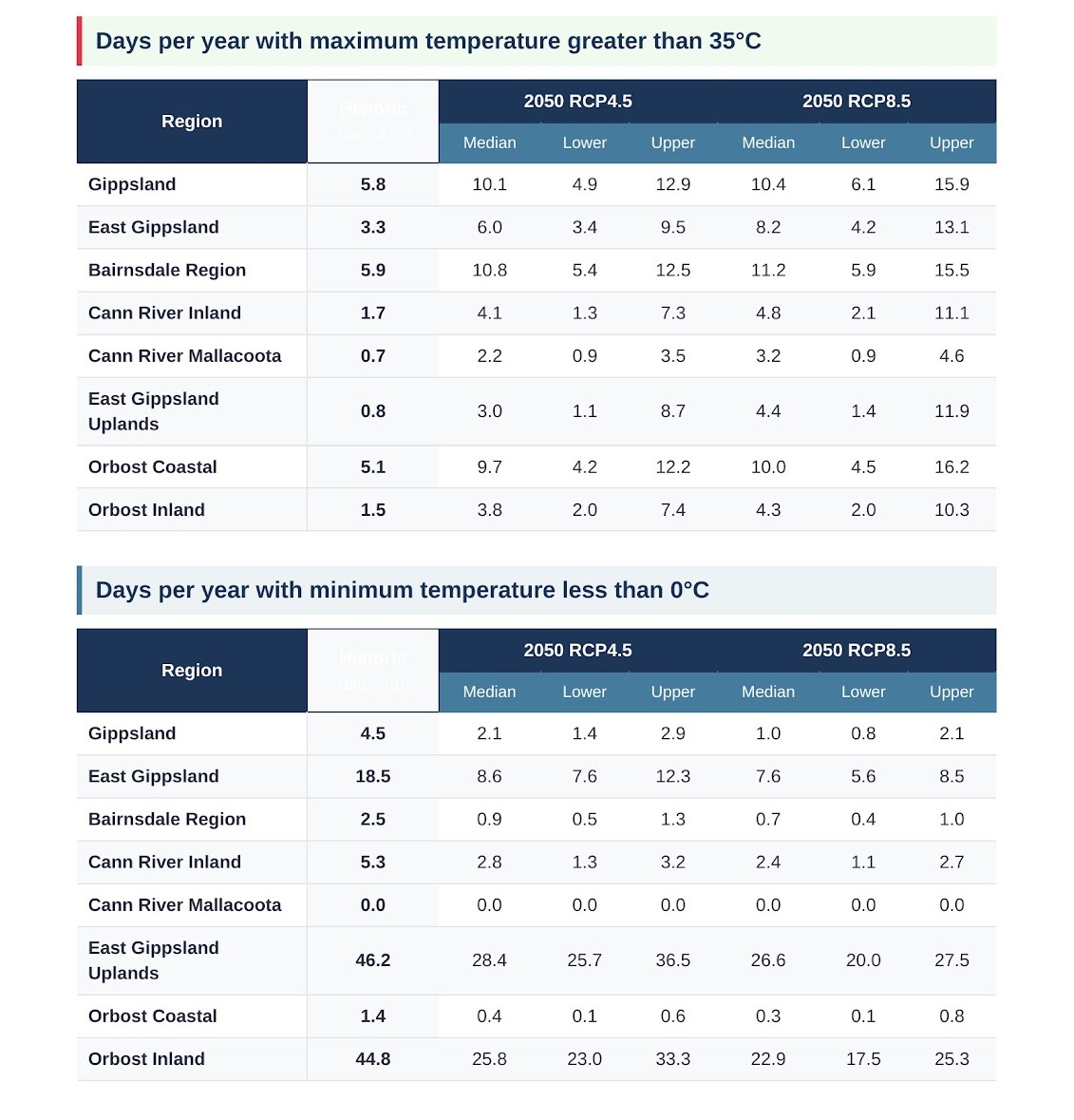
The climate data used here shows how East Gippsland’s weather is expected to change in the future compared to the past. Scientists looked at detailed climate simulations covering the region and compared future conditions to a historical baseline from 1986 to 2005.
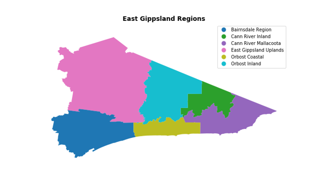
These projections are based on high-resolution modelling (at a 5 km scale), which helps us understand what changes might happen in different parts of East Gippsland. The results include expected shifts in temperature, rainfall, and extreme weather across the whole shire and its sub-regions.
A summary of East Gippsland climate is expected to experience warmer and drier conditions by 2030 and 2050 under both medium and high greenhouse gas emissions scenarios.
Temperature
By 2030, average maximum temperatures may rise by 1.1°C under both medium (RCP4.5) and high (RCP8.5) emissions.
By 2050, increases could reach 1.8°C (RCP4.5) and 1.9°C (RCP8.5).
Average Temperature
Mean annual temperatures are projected to increase by 0.9°C by 2030 (RCP4.5), and up to 1.7°C by 2050 under high emissions.
Rainfall
Annual rainfall may decrease by 3.6% by 2030 (RCP4.5) and 9.1% by 2050 (RCP8.5), with seasonal variability expected.
Extreme Heat Days
Historically, East Gippsland experienced around 3 days per year over 35°C.
By 2050, this could increase to 6 days under RCP4.5 and 8 days under RCP8.5.
These projections highlight the importance of climate adaptation and resilience planning for our region. Council is using this data to inform infrastructure upgrades, emergency preparedness, and community engagement as part of its long-term sustainability strategy.
Data are provided for two future greenhouse gas emissions scenarios, called Representative Concentration Pathways
RCP4.5 - a medium emissions pathway
RCP8.5 - a high emissions pathway
Community Emissions Snapshot
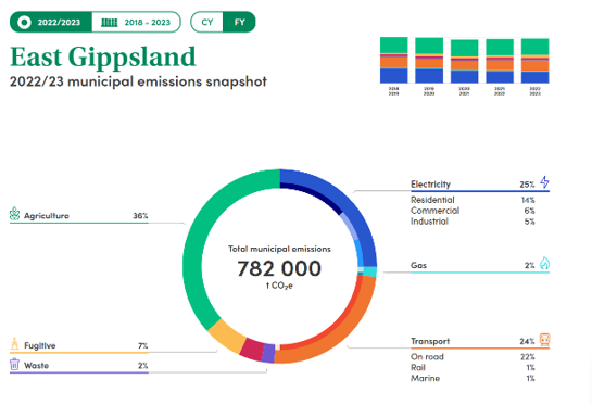
East Gippsland’s community emissions profile highlights the region’s unique environmental footprint. According to the Snapshot Climate tool, the municipality emits approximately 782,000 tonnes of CO₂ equivalent annually. The largest contributors are:
Agriculture (36%) – reflecting the region’s strong farming sector
Transport (24%) – primarily on-road vehicle use
Electricity consumption (25%) – across residential, commercial and industrial sectors
As a rural region with low urban density, East Gippsland faces distinct challenges in reducing emissions. Council has identified this as priority, as a goal of the Environmental Sustainability Strategy 2022–2032 is to support community participation in the climate response.
Through this strategy, Council is working to:
Manage and mitigate climate change impacts
Promote sustainable resource use
Support low-emissions transport options
Encourage community participation in climate action
Protect biodiversity and regenerate natural ecosystems
Working Together for a Sustainable Future
Council recognises that meaningful change requires collaboration. By working with residents, businesses, Traditional Owners, and regional partners, East Gippsland is building a more resilient and climate-conscious community.
What can you do?
Learn ways to reduce your electricity bills with some quick tips.
The Building Resilience booklet has been developed for East Gippsland homeowners, businesses and residents. It summarises a large volume of information into the most relevant risks and actions that can be undertaken when building or altering a house.
Integrated Water Management
Water plays a vital role in our urban landscapes, from the water we drink, to the rivers and wetlands flowing through our towns, and how we capture and manage stormwater in our neighbourhoods. This system is known as the urban water cycle.
To manage it more effectively, Council has adopted an approach called Integrated Water Management (IWM). IWM considers the whole water system and focuses on managing it in a more connected, sustainable way.
By understanding how all parts of the water cycle interact, IWM helps identify smarter solutions that deliver multiple benefits, healthier communities, a thriving environment, and long-term economic value.
Our work is guided by the East Gippsland Strategic Directions Statement and the Bairnsdale Integrated Water Management Plan, which set out a clear vision and priorities for water management in the region. These plans identify local opportunities to improve water use, liveability, and environmental outcomes, supporting the long-term sustainability of Bairnsdale and surrounding areas.
Building on this direction, a Lakes Entrance Integrated Water Management Plan is now in development. It will address the town’s unique water challenges and support more coordinated, sustainable management of stormwater, wastewater, and waterway health, aligning with regional strategies to build a more water-resilient East Gippsland.
Related Documents
No items found.
Success! Your feedback was successfully submitted.
There was an error with your submission - please try again.